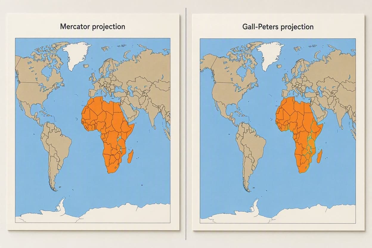
Maps are more than just tools for navigation; they are reflections of how we see the world. For centuries, the Mercator projection has dominated our classrooms and walls, distorting the size of continents to fit a rectangular grid. Now, the United Nations is advocating for a shift toward more accurate representations, particularly highlighting the true scale of Africa. This move is not just about geometry; it is about perspective and respect. The Mercator projection, developed in the 16th century, greatly exaggerates the size of landmasses near the poles, such as Europe and North America, while shrinking those near the equator, like Africa. As a result, Africa appears much smaller than it actually is, despite being the second-largest continent. The UN’s initiative aims to correct this misconception by promoting projections like the Gall-Peters or AuthaGraph, which preserve area accuracy. It is a step toward visual equity.
This distortion has had subtle but profound effects on global perception. By minimizing Africa’s size, the map inadvertently reinforces a narrative of marginalization. Correcting this visual bias helps to acknowledge the continent’s vast resources, diverse cultures, and significant role in global affairs. It is a symbolic gesture that carries weight in education and diplomacy. Seeing the world accurately is the first step to understanding it fairly.
Educators and cartographers have long debated the best way to represent the globe on a flat surface. No projection is perfect, as transforming a sphere into a plane always involves some compromise. However, the choice of projection reveals our priorities. The UN’s support for area-accurate maps signals a commitment to truth and inclusivity. It encourages a more balanced view of global geography.
The initiative includes updating educational materials and official documents used by UN agencies. Schools around the world are encouraged to adopt these new standards, helping students develop a more realistic understanding of global proportions. This change may seem small, but its impact on young minds could be significant. It fosters a sense of global citizenship rooted in factual awareness.
Critics argue that changing familiar maps may cause confusion. However, proponents believe that the benefits of accuracy outweigh the temporary discomfort. In an age of information, precision is valued. Updating our maps is part of a broader effort to decolonize knowledge and challenge inherited biases. It is about aligning our tools with our values of equality and justice.
Africa’s true size is staggering, covering over 30 million square kilometers and home to 54 countries. Recognizing this magnitude helps to contextualize its economic potential and environmental importance. From the Sahara to the Congo Basin, the continent’s diversity is mirrored in its vast expanse. Accurate maps allow us to appreciate this scale properly.
The UN has launched a campaign to raise awareness about map projections, inviting educators and policymakers to join the effort. As more institutions adopt accurate representations, our collective image of the world becomes clearer and more just. It is a small change with a large implication.
AI Image Disclaimer: Any images used in conjunction with this article are AI-generated simulations and do not represent actual photographic evidence from the scene.
Sources: UN News National Geographic The Guardian BBC Future
Published by Banx Network. This article is part of the Banx decentralized media programme, powered by the BXE token on the XRP Ledger.