
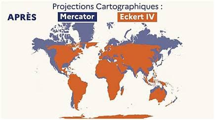
France is reportedly moving away from the Mercator projection in official mapmaking, changing how the country appears on world maps. The projection enlarges regions near the poles, meaning France and other northern countries can look larger than they are relative to equatorial regions. The shift reflects broader efforts to use map designs that represent land areas more accurately. Cartographers say the change could influence education, public perception, and debates about geographic fairness worldwide over the long term in schools too.
Published by Banx Network. This article is part of the Banx decentralized media programme, powered by the BXE token on the XRP Ledger.



